Turn off Drawing Outline
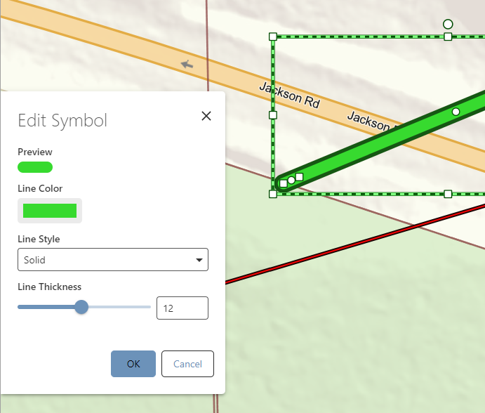
PlanifiéeMultiple users want to be able to turn off the outline on drawings/measurements. The only workaround is turning the line style to None, but then the Line Color doesn't = the remaining line. It seems to dynamically calculate it for contrast with the non-existing line, so it's not user intuitive when picking a color.
-

Team has discussed this, some idea of a future option to “Turn off Accessiblity compliance”
6 -

Hi Cam! Status is set to planned, as far as I can see - when can we expect this to be implemented? Our users are really annoyed by the forced outline as well. In general, we don't agree with the forced web accessibility (we use VS in-house), and we hope to see a possibility for switching off ALL web accessibility options in the user interface (as an administrator at least).
6 -

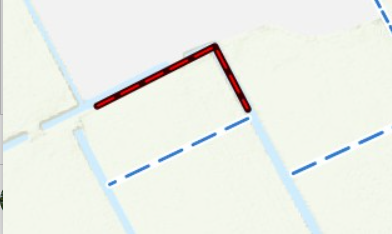
Is there any progress regarding this subject? Our users complain about the contrast / accesibility markup as well. In the screenprint below for instance, the blue dotted line has a white background. In my opinion this should be transparant. Same goes for the red dotted line. This line is given a forced black background.
 4
4 -

Hi we agree on this. It would be very usefull to be able to switch on/off the web accesibility compliance as administrator!
3 -

Yes, I agree that this option would be very useful. We have issues with requirements with some legal plans for which the default outline is not acceptable.
3 -

I can see that idea is marked as planned. Do you have any updates on when it will be implemented?
3 -

As a cartographic product its very important to the users to be able to set as much as possible on theier own way.
3 -
Any news on this? Now the last update is more than a year ago and we have daily issues with this.
We have many of the urban planners in municipality migrated to VertiGIS Studio Web for their WebGIS solution but they can't do some of their workflows as they used to in Web App Builder because they can't choose symbols that live up to the legal standards they have to. It is therefore not just a problem of visual preference but to actually align with national standards of geodataproduction
3 -
I'd welcome some positive news on this too. As with Olivia's comments, for us it is an issue preventing our Legal department from producing compliant maps themselves.
1
Vous devez vous connecter pour laisser un commentaire.
Commentaires
9 commentaires