Feature Comparison Matrix: Is feature X that was in GVH available in VSW yet?
Épinglée En avant
A common (and completely fair) question when looking at VertiGIS Studio Web is trying to understand if a feature that existed in the Geocortex Viewer for HTML5 (GVH) already exists in VertiGIS Studio Web (VSW).
In a recent show-and-tell webinar I presented some information on how to begin thinking about the transition from GVH to VSW and how to get ready for it.
During that presentation I shared a not-pretty-but-effective spreadsheet matrix that I keep up to date that helps map functionality between the two products.
At a minimum this view will help you understand if something already exists, and if I've indicated it does, then you can ask additional questions about how to access that functionality if it isn't immediately obvious in Designer.
Questions and comments are always welcome, that is the purpose of this community forum!
https://data.latitudegeo.com/Cam/gvh-vsw-feature-matrix.pdf
Items in yellow are new in the latest version.
- Updated to reflect the release of VertiGIS Studio Web 5.37 -
Cam
-

(replying for future notification)
0 -

Can I request fine-tuning of the layer catalog functionality in a future release? What was exposed recently as a "Layer Catalog" with the tags is really better described as a portal item gallery. We used to be able to compartmentalize layers into separate catalogs by category and then ingest them into a viewer together. That grouping was critical and the most important aspect of the former catalog sites in my opinion. The tagging is just a huge gallery of all the layers exposed at once.
The current format also only lets you chose one layer at a time which should be changed to multiple selections. I realize this is the first launch of it, so please consider this feature feedback, post-release.
 2
2 -
Hi @Jamie Petersen? Your requests are in keeping with planned future work. The tags already give the creator the ability to organize the layers into different buckets, and to include (or not) those buckets for particular apps. The big thing that is missing from what I see in your comments is that the end-user needs UI to toggle the categories off and on. Between that new ability and the search/filter you have pretty equivalent capability. (and the need to multi-select).
0 -
Someone asked recently ... "Is this post up to date?"
Yes, indeed. I update the .PDF that the post links to with each release.
Check top of the PDF for the GXW version to confirm when you open the PDF.
0 -
Updated for 5.16 - a few really cool new features in 5.16 that don't necessarily show up in the matrix (in particular check out how we enhanced layer presets). I know many of you are eagerly awaiting ootb feature editing tools. The entire team is focused on this so that they will be available in 5.17 (they are close).
0 -
An updated version of the feature matrix has been linked to this article for 5.17
0 -
It's updated for 5.17
0 -

Greatly appreciate all the hard work on Vertigis Studio Web (VSW), has come a long way. We have migrated all of our worflows, reports, and printing to the newest Vertigis Studio versions, but we are still using Geocortex Viewer for HTML5 (GVH) for our viewer application. The biggest reason we haven't migrated to VSW is the save/open project functionality. I see that in the current release of VSW that it is file based. Are there any plans to make all of this served based like it is currently configured in GVH? Maybe store the project information somehow in AGOL/Portal? I'm sure it's complicated, but that would be a huge improvement, file based saving of projects seems like a step backward from current functionality. Thanks again Cam!
0 -
Jeff DeWitt We could likely add the functionality to add/retrieve projects from an Esri Portal ... I've hesitated to do this work so far because of the licensing implications. For your organization, are you OK with requiring every user who is creating projects (write to Portal) to be a Creator user? -Cam
0 -
Ahh, yes that makes sense as they would have to be able to add "content" in the Portal. In our particular scenario, yes it shouldn't be an issue having them all be Creator users. Assuming that could be done, would this likely be a custom implementation or be part of the core product?
0 -
The feature matrix has been updated to reflect the Web 5.18 release.
0 -

Regarding saved projects in Portal--I would prefer that not be the only option as we are seriously lacking Creator licenses relative to our overall internal user base. I'm unsure exactly where you are currently storing the saved file (locally on the user's machine?) but it would be awesome to be able to specify a save location on a file share on our network. This would be a central repository plus more likely to be backed up. But I'm guessing that adds a level or two of complexity due to permissions and security for that storage location.
2 -
Cam, any idea when Data Linking might get addressed? How about hidden layers in the TOC?
1 -

I agree with Brian. We have 600 Viewers that can save Sessions, Bookmarks etc as a Viewer and we would like to continue to have that capability in Web.
0 -
Brian Oevermann Ted Cronin ... loud and clear, I've got a solution in the works that will work with any Esri user type (even a free viewer) for sharing projects.
2 -
Brian Oevermann Data Linking is pretty far along, but wasn't quite far enough to make this release. Can you elaborate on what you mean by hidden layers in the TOC?
0 -
Cam, regarding "hidden layers"...
I have features in basemaps, such as streets, and streams, as well as a cached address point layer that Essentials is unable to identify against (perhaps I'm just doing something wrong). To mitigate that I created a "basemap identify" map service and added it to my viewer. In Essentials, I uncheck the "Show in Layer List" option (and hide all of the sub-layers as well) and also uncheck the "Show in Legend" option for this map service. When the user identifies on a street or address point, for example, they get the relevant results. They simply don't realize those results are coming from a different map service than the one they see. I hope I explained that adequately!
Perhaps there is a better way to do this in Web? I'm guessing my example is one of many potential use cases that customers are unchecking a map service to not show in the layer list.
0 -

Brian Oevermann I had a support case open for exactly this question. The support analyst showed me some enhancements that were included in 5.16 that allow for just that. On in the map, so it can query, but off in the layer list so as not to be noticed or turned off.
 2
2 -
Jamie Petersen, Thank you for this! I'll explore a bit. My initial goal is to have a Web equivalent to my Essentials HTML5 viewer and then begin taking advantage of the new capabilities. Lack of Data Links is slowing down that progress! But this gives me something else to experiment with.
0 -
Matrix updated based on the 5.19 release.
0 -
Feature matrix updated to reflect 5.21 release.
0 -

Cam, Do you have a release in mind for the QueryBuilder functionality? Do you think it will make 5.22, or will a later release be more realistic?
1 -
Wout Peters The query builder is coming along, but it won't make 5.22 (February), It may be ready for 5.23 (April) but certainly not guaranteed. I'd be disappointed if we don't have it finished up by 5.24 (June).
0 -
Cam Barnard Can we get a splash screen or terms of use component? It says Not Planned in the matrix. I need that feature. I see splash screens on many html5 sites, especially government sites. I found another recent thread in this same community of someone else asking for it in vertigis studio web. The workaround was a custom dialog method. I'd like to see a built-in component incorporated into the product. I'm not sure why it wasn't planned to be ported over, but I'd like to advocate for it being implemented. Thank you!
2 -
Updated for 5.24 (June 21)
1 -

Hi Cam,
Can you please confirm where we find the following equivalent HTML5 functionality in VS Web:
- Toggle visibility of layer labels on/off?
- Geolocation - Follow Me?
- Geolocation - Track Me?
- Feature Clustering and Heat Maps - I realise these are now configured in the webmap but does the end user have any options to adjust the intensity of the heat map display or clustering sizes as they currently do in the HTML5 viewer via the Visualisation Options?
Thanks
Kind regards, Gael
0 -
Hi Gael Cutress.
#1 is available (for layers that support it) you can try it out on the Web GIS - Default template using the Neighbourhoods layer. In the three-dot actions menu in the layer list you'll see a "Show Layer Labels" or "Hide Layer Labels" option (depending on whether they are currently on or off).
#2 / #3 - we haven't implemented this yet.
#4 - correct, all currently configured in the Webmap, we haven't yet included any end-user adjustment of these.
0 -

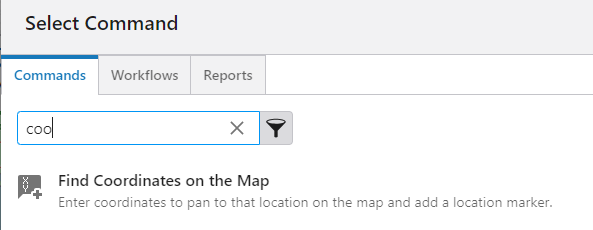
I see that a locate coordinate & lat/long tool is supposed to be available but I haven't been able to find it to add it in Web. Can you point me in the right direction? It looks like it's been available since 5.15-17 and I'm on 5.25. I'm thinking of an equivalent to the Plot Coordinates tool with user-entered coordinates plotted on the map.
https://docs.vertigisstudio.com/webviewer/latest/admin-help/whats-new.html
Added a new tool allowing end users to enter coordinates to find the location represented by those coordinates on the map.
0 -
Heather Widlund ... via a tool in the toolbar or an I Want To Menu item you can use this command
 0
0 -
Thank you, Cam Barnard! I was just looking in the wrong place, of course.
0
Vous devez vous connecter pour laisser un commentaire.
Commentaires
82 commentaires