Label Settings Not Working after 5.43.2 Upgrade

After upgrading to 5.43.2 the label settings for layers added as a map service are greyed out. Has anyone else experienced this in their application after installing 5.43.2? I believe this bug was introduced in the previous version, but got worse with the 5.43.2 upgrade. If I add the layers as a feature layer the label settings are not greyed out.
Application Link: https://dnrmaps.wi.gov/H5/?viewer=Well_Driller_Viewer
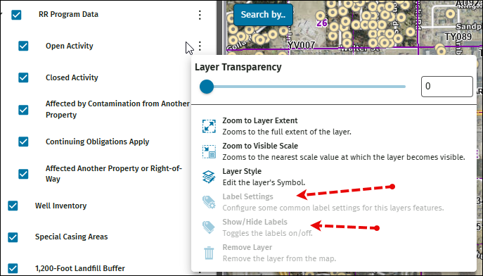
In the previous version 5.41.2 the Label Settings wouldn't show in the list but once an identify was performed on any of the layers within that map service then the Label Settings were present.
We have opened a ticket to VertiGIS Support in regards to this, but thought I'd put it out here in case others are having the same issue and maybe they determined the solution.
-

Hi Raquel,
I've been dealing with the same issue related to label settings. I also found that adding the label settings for individual map services does work but not for anything coming from a full map service. Although, I did not know about your work around using identify. I also have a ticket open, but interesting to know others are dealing with the same issue.
Thanks
1 -
Holger,
Thanks for info..
In regards to his comment ‘expected behavior’ I am not sure about that. As this was not the behavior in the release prior to 5.41.2, the label settings were always present as long as the Map Service had them enabled or the labels were enabled in the underlying web map for that specific layer. We didn't even have to identify a feature to make the Label Settings appear.
Also, if this is ‘expected behavior’ then why isn't it documented in the VertiGIS documentation or even in the What's New..
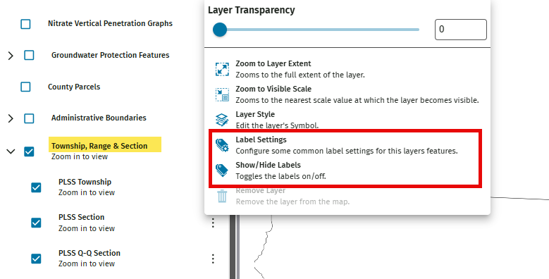
If you look at my application and go to the Township, Range & Section layers and click on the 3 dots, the label Settings are present and I am able to override the labels. This is the behavior it has always been prior to the 5.41.2 release. So if the ‘expected behavior’ of the label settings to not be present why is it present here? This application is running on 5.43.2.
0 -

I submitted the ticket that Raquel is speaking of. I got this reply:
"This behavior does appear to align with a recently filed bug:
397509 - "Show/hide labels" layer action is unavailable for map service layers after Identify is used.and
“It looks like the underlying issue concerns label configuration being disabled on certain map types after an 'Identify' is run”
Questions to this group:
1) What map types is this impacting and which ones does it not impact? I wonder if we can use this knowledge as a workaround till this is addressed.
2) Does anyone know how a given tool is disabled? Knowing that, I wonder if we can force the tool to remain enabled…also as possible a workaround till this is addressed.
0

Please sign in to leave a comment.
Comments
4 comments