Identify Polygon as a drawing
Hi all
I would like to be able to display the Area Identified as a drawing. For example.. I draw a polyon and buffer it (as part of the identify tool) The Buffer area can be added as a drawing but not the area I actually identified. Any ideas?
Thanks in advance
Using the latest HTML5 viewer
0
-

Hi Chris,
You could set up a workflow that- gets the user to draw a polygon
- adds the polygon to the map as a drawing
- runs the identify command on the polygon they drew
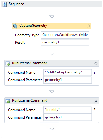
(the cut off text in CaptureGeometry is Geocortex.Workflow.Activities.GeometryCaptureType.FreehandPolygon)
If you'd prefer that option be built into the identify tool itself instead of a separete workflow on the toolbar, then I would recommend posting that request in the Ideas section (https://support.geocortex.com/GSCIdeas?c=09a6000000008RsAAI&filter=1&categ=all?-nav=ideas&main-nav=essentials&page=1) .
Hope that helps!
-Amanda0
Bitte melden Sie sich an, um einen Kommentar zu hinterlassen.
Kommentare
1 Kommentar