VSW5.28.1: How to search a particular feature based on 3 fields?

VSW5.28.1: How to search a particular feature based on 3 fields?
For example, as per the screenshot below, I wanted to build a workflow that searches a parcel based on ParcelNumber, BlockNumber and CommunityName_Arabic and zoom to feature but couldn’t figure out how this might be developed
Map service:
https://orthophotos.geomolg.ps/adaptor/rest/services/ParcelsRegistered_11/MapServer
Please find below the link for the workflow of first trial, as it runs, it neither bring up an error or a result
https://www.mediafire.com/file/qyk7r9c26uuj7bn/ParcelSearch.json/file

What could be the issue here
I will be very happy for any help
Best,
Lubna
-

Moved to this topic as it's more relevant for troubleshooting questions rather than ideas for new features.
0 -
Thank you Ken,
I worked on it and built a workflow for the above query
0 -
Lubna,
I'm glad to hear you found a solution.
0 -
Dear Ken Lyon,
I need to enhance the workflow to be general, so make the end user fill any fields he want (not necessary 4 values), below the workflow that I had, what could be the proper way to give the end user all 15 possibilities
It will be very appreciated for your suggestion according the best practice
{
"_properties": {
"isServerWorkflow": false
},
"components": [
{
"id": 2,
"steps": [
{
"id": 3,
"inputs": {},
"position": "0,0",
"purpose": "start",
"title": "Start",
"transitions": [
{
"id": 61,
"inputs": {},
"position": "90,60 90,160",
"sourceConnector": "bottom",
"target": {
"id": 25
}
}
]
},
{
"action": "gcx:wf:core::Container",
"id": 25,
"inputs": {},
"position": "-30,160",
"title": "Setup",
"transitions": [
{
"id": 154,
"position": "90,250 90,300 100,300 100,320",
"sourceConnector": "bottom",
"target": {
"id": 151
}
}
]
},
{
"action": "gcx:wf:core::If",
"id": 65,
"inputs": {
"condition": {
"accessors": [
"$DisplayForm"
],
"annotations": [
{
"count": 12,
"index": 0,
"kind": "idref"
}
],
"code": "$DisplayForm.result === \"Submit\"",
"source": "$DisplayForm.result === \"Submit\""
}
},
"position": "80,520",
"title": "If",
"transitions": [
{
"branch": "false",
"id": 218,
"position": "200,550 320,550 320,520 430,520 430,540",
"sourceConnector": "right",
"target": {
"id": 200
},
"targetConnector": "top"
},
{
"branch": "true",
"id": 350,
"position": "80,550 0,550 0,530 -140,530 -140,550",
"sourceConnector": "left",
"target": {
"id": 347
},
"targetConnector": "top"
}
]
},
{
"action": "gcx:wf:forms:form:DisplayForm",
"id": 151,
"inputs": {
"form": {
"accessors": [],
"code": "resources.forms[values.id]",
"values": {
"id": 149
}
}
},
"name": "DisplayForm",
"position": "-20,320",
"title": "Display Form",
"transitions": [
{
"id": 155,
"position": "100,440 100,500 140,500 140,520",
"sourceConnector": "bottom",
"target": {
"id": 65
}
}
]
},
{
"action": "gcx:wf:core::Exit",
"id": 200,
"inputs": {},
"position": "340,540",
"title": "Exit"
},
{
"action": "gcx:wf:core::Container",
"description": "Parcel+Block+Quarter+Community",
"id": 347,
"inputs": {},
"position": "-260,550",
"title": "Parcel+Block+Quarter+Community",
"transitions": [
{
"id": 467,
"position": "-260,620 -440,620 -440,690",
"sourceConnector": "left",
"target": {
"id": 466
},
"targetConnector": "top"
}
]
},
{
"action": "gcx:wf:core::Container",
"description": "Parcel+Block+Quarter",
"id": 385,
"inputs": {},
"position": "-380,800",
"title": "Parcel+Block+Quarter",
"transitions": [
{
"id": 472,
"position": "-380,860 -510,860 -510,920",
"sourceConnector": "left",
"target": {
"id": 471
},
"targetConnector": "top"
}
]
},
{
"action": "gcx:wf:core::Container",
"description": "Parcel+Block",
"id": 423,
"inputs": {},
"position": "-400,1020",
"title": "Parcel+Block",
"transitions": [
{
"id": 477,
"position": "-280,1140 -280,1160 -440,1160 -440,1130 -520,1130 -520,1150",
"sourceConnector": "bottom",
"target": {
"id": 476
},
"targetConnector": "top"
}
]
},
{
"action": "gcx:wf:core::Container",
"description": "Parcel",
"id": 461,
"inputs": {},
"position": "-390,1230",
"title": "Parcel"
},
{
"action": "gcx:wf:core::If",
"id": 466,
"inputs": {
"condition": true
},
"position": "-500,690",
"title": "If",
"transitions": [
{
"branch": "false",
"id": 479,
"position": "-380,720 -260,720 -260,800",
"sourceConnector": "right",
"target": {
"id": 385
},
"targetConnector": "top"
},
{
"branch": "true",
"id": 495,
"position": "-500,720 -710,720 -710,770",
"sourceConnector": "left",
"target": {
"id": 494
},
"targetConnector": "top"
}
]
},
{
"action": "gcx:wf:core::If",
"id": 471,
"inputs": {
"condition": true
},
"position": "-570,920",
"title": "If",
"transitions": [
{
"branch": "false",
"id": 480,
"position": "-450,950 -280,950 -280,1020",
"sourceConnector": "right",
"target": {
"id": 423
},
"targetConnector": "top"
}
]
},
{
"action": "gcx:wf:core::If",
"id": 476,
"inputs": {
"condition": true
},
"position": "-580,1150",
"title": "If",
"transitions": [
{
"branch": "false",
"id": 481,
"position": "-460,1180 -270,1180 -270,1230",
"sourceConnector": "right",
"target": {
"id": 461
},
"targetConnector": "top"
}
]
},
{
"action": "gcx:wf:ui::Alert",
"id": 494,
"inputs": {
"text": "غغغغغ"
},
"position": "-830,770",
"title": "Alert"
}
]
},
{
"id": 9,
"steps": [
{
"id": 11,
"inputs": {},
"position": "0,0",
"purpose": "start",
"title": "Container",
"transitions": [
{
"id": 15,
"inputs": {},
"position": "90,60 90,130",
"sourceConnector": "bottom",
"target": {
"id": 13
}
}
]
},
{
"action": "gcx:wf:core::Container",
"id": 13,
"inputs": {},
"position": "-30,130",
"title": "Variables"
}
]
},
{
"id": 17,
"steps": [
{
"id": 19,
"inputs": {},
"position": "0,0",
"purpose": "start",
"title": "Container",
"transitions": [
{
"id": 121,
"position": "90,60 90,130 100,130 100,150",
"sourceConnector": "bottom",
"target": {
"id": 120
},
"targetConnector": "top"
}
]
},
{
"action": "gcx:wf:core::CreateValue",
"description": "Used to store selected features from chosen query",
"id": 120,
"inputs": {
"expression": {
"accessors": [],
"annotations": [],
"code": "[]",
"source": "[]"
}
},
"name": "selectedFeatures",
"position": "-20,150",
"title": "Selected Features List"
}
]
},
{
"id": 125,
"steps": [
{
"id": 127,
"inputs": {},
"position": "0,0",
"purpose": "start",
"title": "Event",
"transitions": [
{
"id": 139,
"inputs": {},
"position": "90,60 90,110",
"target": {
"id": 129
}
}
]
},
{
"action": "gcx:wf:forms::GetFormEventData",
"description": "Get the current value from the AutoComplete element.",
"id": 129,
"inputs": {
"form": {
"accessors": [
"$$form"
],
"annotations": [
{
"count": 6,
"index": 0,
"kind": "idref"
}
],
"code": "$$form",
"source": "$$form"
}
},
"name": "getFormEventData1",
"position": "-30,110",
"title": "Get Form Event Data",
"transitions": [
{
"id": 141,
"inputs": {},
"position": "90,220 90,270",
"target": {
"id": 131
}
}
]
},
{
"action": "gcx:wf:core::TextReplace",
"description": "Escape apostrophe characters to avoid SQL injection and broken queries.",
"id": 131,
"inputs": {
"newValue": "''",
"oldValue": "'",
"text": {
"accessors": [
"$getFormEventData1"
],
"annotations": [
{
"count": 18,
"index": 0,
"kind": "idref"
}
],
"code": "$getFormEventData1.argument",
"source": "$getFormEventData1.argument"
}
},
"name": "textReplace1",
"position": "-30,270",
"title": "Text Replace",
"transitions": [
{
"id": 143,
"inputs": {},
"position": "90,400 90,450",
"target": {
"id": 133
}
}
]
},
{
"action": "gcx:wf:arcgis:query:QueryTask",
"description": "Query for features.",
"id": 133,
"inputs": {
"outFields": "CommunityName_Arabic",
"returnGeometry": false,
"url": "https://lubnaj-pc.molg.pna.ps/adaptor/rest/services/Parcels/MapServer/1",
"where": {
"accessors": [
"$textReplace1"
],
"annotations": [
{
"count": 13,
"index": 43,
"kind": "idref"
}
],
"code": "\"UPPER(CommunityName_Arabic) LIKE UPPER('\".concat($textReplace1.result, \"%')\")",
"source": "`UPPER(CommunityName_Arabic) LIKE UPPER('${$textReplace1.result}%')`"
}
},
"name": "query1",
"position": "-30,450",
"title": "Query Layer",
"transitions": [
{
"id": 145,
"inputs": {},
"position": "90,550 90,600",
"target": {
"id": 135
}
}
]
},
{
"action": "gcx:wf:forms::GetFormElementItemsFromFeatures",
"description": "Convert the features into form element items to be used in the element.",
"id": 135,
"inputs": {
"features": {
"accessors": [
"$query1"
],
"annotations": [
{
"count": 7,
"index": 0,
"kind": "idref"
}
],
"code": "$query1.features",
"source": "$query1.features"
},
"labelFieldName": "CommunityName_Arabic",
"valueFieldName": "CommunityName_Arabic"
},
"name": "formElementItems1",
"position": "-30,600",
"title": "Get Form Element Items From Features",
"transitions": [
{
"id": 147,
"inputs": {},
"position": "90,730 90,780",
"target": {
"id": 137
}
}
]
},
{
"action": "gcx:wf:forms::SetFormElementItems",
"description": "Assign form element items to the element.",
"id": 137,
"inputs": {
"form": {
"accessors": [
"$$form"
],
"annotations": [
{
"count": 6,
"index": 0,
"kind": "idref"
}
],
"code": "$$form",
"source": "$$form"
},
"items": {
"accessors": [
"$formElementItems1"
],
"annotations": [
{
"count": 18,
"index": 0,
"kind": "idref"
}
],
"code": "$formElementItems1.items",
"source": "$formElementItems1.items"
}
},
"position": "-30,780",
"title": "Set Form Element Items"
}
],
"title": "suggest-CommunityName"
},
{
"id": 315,
"steps": [
{
"action": "gcx:wf:core::If",
"id": 317,
"inputs": {
"condition": {
"accessors": [
"$queryParcel9"
],
"annotations": [
{
"count": 13,
"index": 0,
"kind": "idref"
}
],
"code": "$queryParcel9.features.length == 0",
"source": "$queryParcel9.features.length ==0"
}
},
"position": "30,270",
"title": "If",
"transitions": [
{
"branch": "false",
"id": 335,
"inputs": {},
"position": "150,300 170,300 170,380 -160,380 -160,400",
"sourceConnector": "right",
"target": {
"id": 323
},
"targetConnector": "top"
}
]
},
{
"id": 319,
"inputs": {},
"position": "0,0",
"purpose": "start",
"title": "Container",
"transitions": [
{
"id": 337,
"inputs": {},
"position": "90,60 90,120",
"sourceConnector": "bottom",
"target": {
"id": 327
}
}
]
},
{
"action": "gcx:wf:core::SetProperty",
"id": 323,
"inputs": {
"object": {
"accessors": [
"$selectedFeatures"
],
"annotations": [
{
"count": 17,
"index": 0,
"kind": "idref"
}
],
"code": "$selectedFeatures",
"source": "$selectedFeatures"
},
"propertyName": "result",
"propertyValue": {
"accessors": [
"$queryParcel9"
],
"annotations": [
{
"count": 13,
"index": 0,
"kind": "idref"
}
],
"code": "$queryParcel9.features",
"source": "$queryParcel9.features"
}
},
"position": "-280,400",
"title": "Set Selected Features",
"transitions": [
{
"id": 339,
"inputs": {},
"position": "-160,430 -160,490",
"sourceConnector": "bottom",
"target": {
"id": 329
}
}
]
},
{
"action": "gcx:wf:arcgis::SetViewExtent",
"id": 325,
"inputs": {
"geometry": {
"accessors": [
"$getFeatureSetExtent9"
],
"annotations": [
{
"count": 21,
"index": 0,
"kind": "idref"
}
],
"code": "$getFeatureSetExtent9.extent",
"source": "$getFeatureSetExtent9.extent"
}
},
"name": "setMapExtent9",
"position": "-280,600",
"title": "Set Map Extent",
"transitions": [
{
"id": 341,
"inputs": {},
"position": "-160,670 -160,780",
"sourceConnector": "bottom",
"target": {
"id": 331
},
"targetConnector": "top"
}
]
},
{
"action": "gcx:wf:arcgis:query:QueryTask",
"id": 327,
"inputs": {
"groupByFieldsForStatistics": "CommunityName_Arabic",
"layer": "Parcels_04",
"outFields": "*",
"returnDistinctValues": false,
"returnGeometry": true,
"url": "https://lubnaj-pc.molg.pna.ps/adaptor/rest/services/Parcels/MapServer/0",
"where": {
"accessors": [
"$DisplayForm",
"$DisplayForm",
"$DisplayForm",
"$DisplayForm"
],
"annotations": [
{
"count": 12,
"index": 27,
"kind": "idref"
},
{
"count": 12,
"index": 95,
"kind": "idref"
},
{
"count": 12,
"index": 170,
"kind": "idref"
},
{
"count": 12,
"index": 240,
"kind": "idref"
}
],
"code": "\"((QuarterNumber) LIKE ('\".concat($DisplayForm.state.Quarterno.value, \"')) AND ((ParcelNumber) LIKE ('\").concat($DisplayForm.state.Parcelno.value, \"')) AND ((CommunityName_Arabic) LIKE ('\").concat($DisplayForm.state.CommunityName.value, \"')) AND((BlockNumber) LIKE ('\").concat($DisplayForm.state.Blockno.value, \"'))\")",
"source": "`((QuarterNumber) LIKE ('${$DisplayForm.state.Quarterno.value}')) AND ((ParcelNumber) LIKE ('${$DisplayForm.state.Parcelno.value}')) AND ((CommunityName_Arabic) LIKE ('${$DisplayForm.state.CommunityName.value}')) AND((BlockNumber) LIKE ('${$DisplayForm.state.Blockno.value}'))`"
}
},
"name": "queryParcel9",
"position": "-30,120",
"title": "Parcels Query",
"transitions": [
{
"id": 333,
"inputs": {},
"position": "90,190 90,270",
"sourceConnector": "bottom",
"target": {
"id": 317
},
"targetConnector": "top"
}
]
},
{
"action": "gcx:wf:arcgis::GetFeatureSetExtent",
"id": 329,
"inputs": {
"features": {
"accessors": [
"$selectedFeatures"
],
"annotations": [
{
"count": 17,
"index": 0,
"kind": "idref"
}
],
"code": "$selectedFeatures.result",
"source": "$selectedFeatures.result"
}
},
"name": "getFeatureSetExtent9",
"position": "-280,490",
"title": "Get Feature Set Extent",
"transitions": [
{
"id": 343,
"inputs": {},
"position": "-160,560 -160,600",
"sourceConnector": "bottom",
"target": {
"id": 325
},
"targetConnector": "top"
}
]
},
{
"action": "gcx:wf:arcgis::SelectFeatures",
"id": 331,
"inputs": {
"features": {
"accessors": [
"$queryParcel9"
],
"annotations": [
{
"count": 13,
"index": 0,
"kind": "idref"
}
],
"code": "$queryParcel9.features",
"source": "$queryParcel9.features"
},
"mapServiceId": {
"accessors": [],
"code": "0",
"source": "0"
}
},
"position": "-280,780",
"title": "Show Results"
}
]
},
{
"id": 353,
"steps": [
{
"action": "gcx:wf:arcgis::SetViewExtent",
"id": 355,
"inputs": {
"geometry": {
"accessors": [
"$getFeatureSetExtent8"
],
"annotations": [
{
"count": 21,
"index": 0,
"kind": "idref"
}
],
"code": "$getFeatureSetExtent8.extent",
"source": "$getFeatureSetExtent8.extent"
}
},
"name": "setMapExtent8",
"position": "-280,600",
"title": "Set Map Extent",
"transitions": [
{
"id": 377,
"inputs": {},
"position": "-160,670 -160,780",
"sourceConnector": "bottom",
"target": {
"id": 361
},
"targetConnector": "top"
}
]
},
{
"action": "gcx:wf:arcgis:query:QueryTask",
"id": 359,
"inputs": {
"layer": "Parcels_04",
"outFields": "*",
"returnDistinctValues": false,
"returnGeometry": true,
"url": "https://lubnaj-pc.molg.pna.ps/adaptor/rest/services/Parcels/MapServer/0",
"where": {
"accessors": [
"$DisplayForm",
"$DisplayForm",
"$DisplayForm"
],
"annotations": [
{
"count": 12,
"index": 26,
"kind": "idref"
},
{
"count": 12,
"index": 90,
"kind": "idref"
},
{
"count": 12,
"index": 156,
"kind": "idref"
}
],
"code": "\"((ParcelNumber) LIKE ('\".concat($DisplayForm.state.Parcelno.value, \"'))AND((BlockNumber) LIKE ('\").concat($DisplayForm.state.Blockno.value, \"')) AND ((QuarterNumber) LIKE('\").concat($DisplayForm.state.Quarterno.value, \"'))\")",
"source": "`((ParcelNumber) LIKE ('${$DisplayForm.state.Parcelno.value}'))AND((BlockNumber) LIKE ('${$DisplayForm.state.Blockno.value}')) AND ((QuarterNumber) LIKE('${$DisplayForm.state.Quarterno.value}'))`"
}
},
"name": "queryParcel8",
"position": "-30,120",
"title": "Parcels Query",
"transitions": [
{
"id": 373,
"inputs": {},
"position": "90,190 90,270",
"sourceConnector": "bottom",
"target": {
"id": 367
},
"targetConnector": "top"
}
]
},
{
"action": "gcx:wf:arcgis::SelectFeatures",
"id": 361,
"inputs": {
"features": {
"accessors": [
"$queryParcel8"
],
"annotations": [
{
"count": 13,
"index": 0,
"kind": "idref"
}
],
"code": "$queryParcel8.features",
"source": "$queryParcel8.features"
},
"mapServiceId": {
"accessors": [],
"code": "0",
"source": "0"
}
},
"position": "-280,780",
"title": "Show Results"
},
{
"id": 363,
"inputs": {},
"position": "0,0",
"purpose": "start",
"title": "Container",
"transitions": [
{
"id": 379,
"inputs": {},
"position": "90,60 90,120",
"sourceConnector": "bottom",
"target": {
"id": 359
}
}
]
},
{
"action": "gcx:wf:core::SetProperty",
"id": 365,
"inputs": {
"object": {
"accessors": [
"$selectedFeatures"
],
"annotations": [
{
"count": 17,
"index": 0,
"kind": "idref"
}
],
"code": "$selectedFeatures",
"source": "$selectedFeatures"
},
"propertyName": "result",
"propertyValue": {
"accessors": [
"$queryParcel8"
],
"annotations": [
{
"count": 13,
"index": 0,
"kind": "idref"
}
],
"code": "$queryParcel8.features",
"source": "$queryParcel8.features"
}
},
"position": "-280,400",
"title": "Set Selected Features",
"transitions": [
{
"id": 375,
"inputs": {},
"position": "-160,430 -160,490",
"sourceConnector": "bottom",
"target": {
"id": 369
}
}
]
},
{
"action": "gcx:wf:core::If",
"id": 367,
"inputs": {
"condition": {
"accessors": [
"$queryParcel8"
],
"annotations": [
{
"count": 13,
"index": 0,
"kind": "idref"
}
],
"code": "$queryParcel8.features.length == 0",
"source": "$queryParcel8.features.length == 0"
}
},
"position": "30,270",
"title": "If",
"transitions": [
{
"branch": "false",
"id": 371,
"inputs": {},
"position": "150,300 170,300 170,380 -160,380 -160,400",
"sourceConnector": "right",
"target": {
"id": 365
},
"targetConnector": "top"
}
]
},
{
"action": "gcx:wf:arcgis::GetFeatureSetExtent",
"id": 369,
"inputs": {
"features": {
"accessors": [
"$selectedFeatures"
],
"annotations": [
{
"count": 17,
"index": 0,
"kind": "idref"
}
],
"code": "$selectedFeatures.result",
"source": "$selectedFeatures.result"
}
},
"name": "getFeatureSetExtent8",
"position": "-280,490",
"title": "Get Feature Set Extent",
"transitions": [
{
"id": 381,
"inputs": {},
"position": "-160,560 -160,600",
"sourceConnector": "bottom",
"target": {
"id": 355
},
"targetConnector": "top"
}
]
}
]
},
{
"id": 391,
"steps": [
{
"action": "gcx:wf:arcgis::GetFeatureSetExtent",
"id": 393,
"inputs": {
"features": {
"accessors": [
"$selectedFeatures"
],
"annotations": [
{
"count": 17,
"index": 0,
"kind": "idref"
}
],
"code": "$selectedFeatures.result",
"source": "$selectedFeatures.result"
}
},
"name": "getFeatureSetExtent10",
"position": "-280,490",
"title": "Get Feature Set Extent",
"transitions": [
{
"id": 421,
"inputs": {},
"position": "-160,560 -160,600",
"sourceConnector": "bottom",
"target": {
"id": 401
},
"targetConnector": "top"
}
]
},
{
"id": 395,
"inputs": {},
"position": "0,0",
"purpose": "start",
"title": "Container",
"transitions": [
{
"id": 419,
"inputs": {},
"position": "90,60 90,120",
"sourceConnector": "bottom",
"target": {
"id": 405
}
}
]
},
{
"action": "gcx:wf:core::If",
"id": 397,
"inputs": {
"condition": {
"accessors": [
"$queryParcel10"
],
"annotations": [
{
"count": 14,
"index": 0,
"kind": "idref"
}
],
"code": "$queryParcel10.features.length == 0",
"source": "$queryParcel10.features.length == 0"
}
},
"position": "30,270",
"title": "If",
"transitions": [
{
"branch": "false",
"id": 411,
"inputs": {},
"position": "150,300 170,300 170,380 -160,380 -160,400",
"sourceConnector": "right",
"target": {
"id": 399
},
"targetConnector": "top"
}
]
},
{
"action": "gcx:wf:core::SetProperty",
"id": 399,
"inputs": {
"object": {
"accessors": [
"$selectedFeatures"
],
"annotations": [
{
"count": 17,
"index": 0,
"kind": "idref"
}
],
"code": "$selectedFeatures",
"source": "$selectedFeatures"
},
"propertyName": "result",
"propertyValue": {
"accessors": [
"$queryParcel10"
],
"annotations": [
{
"count": 14,
"index": 0,
"kind": "idref"
}
],
"code": "$queryParcel10.features",
"source": "$queryParcel10.features"
}
},
"position": "-280,400",
"title": "Set Selected Features",
"transitions": [
{
"id": 415,
"inputs": {},
"position": "-160,430 -160,490",
"sourceConnector": "bottom",
"target": {
"id": 393
}
}
]
},
{
"action": "gcx:wf:arcgis::SetViewExtent",
"id": 401,
"inputs": {
"geometry": {
"accessors": [
"$getFeatureSetExtent10"
],
"annotations": [
{
"count": 22,
"index": 0,
"kind": "idref"
}
],
"code": "$getFeatureSetExtent10.extent",
"source": "$getFeatureSetExtent10.extent"
}
},
"name": "setMapExtent10",
"position": "-280,600",
"title": "Set Map Extent",
"transitions": [
{
"id": 417,
"inputs": {},
"position": "-160,670 -160,780",
"sourceConnector": "bottom",
"target": {
"id": 407
},
"targetConnector": "top"
}
]
},
{
"action": "gcx:wf:arcgis:query:QueryTask",
"id": 405,
"inputs": {
"layer": "Parcels_04",
"outFields": "*",
"returnDistinctValues": false,
"returnGeometry": true,
"url": "https://lubnaj-pc.molg.pna.ps/adaptor/rest/services/Parcels/MapServer/0",
"where": {
"accessors": [
"$DisplayForm",
"$DisplayForm"
],
"annotations": [
{
"count": 12,
"index": 26,
"kind": "idref"
},
{
"count": 12,
"index": 92,
"kind": "idref"
}
],
"code": "\"((ParcelNumber) LIKE ('\".concat($DisplayForm.state.Parcelno.value, \"')) AND ((BlockNumber) LIKE ('\").concat($DisplayForm.state.Blockno.value, \"'))\")",
"source": "`((ParcelNumber) LIKE ('${$DisplayForm.state.Parcelno.value}')) AND ((BlockNumber) LIKE ('${$DisplayForm.state.Blockno.value}'))`"
}
},
"name": "queryParcel10",
"position": "-30,120",
"title": "Parcels Query",
"transitions": [
{
"id": 413,
"inputs": {},
"position": "90,190 90,270",
"sourceConnector": "bottom",
"target": {
"id": 397
},
"targetConnector": "top"
}
]
},
{
"action": "gcx:wf:arcgis::SelectFeatures",
"id": 407,
"inputs": {
"features": {
"accessors": [
"$queryParcel10"
],
"annotations": [
{
"count": 14,
"index": 0,
"kind": "idref"
}
],
"code": "$queryParcel10.features",
"source": "$queryParcel10.features"
},
"mapServiceId": {
"accessors": [],
"code": "0",
"source": "0"
}
},
"position": "-280,780",
"title": "Show Results"
}
]
},
{
"id": 429,
"steps": [
{
"action": "gcx:wf:arcgis::GetFeatureSetExtent",
"id": 431,
"inputs": {
"features": {
"accessors": [
"$selectedFeatures"
],
"annotations": [
{
"count": 17,
"index": 0,
"kind": "idref"
}
],
"code": "$selectedFeatures.result",
"source": "$selectedFeatures.result"
}
},
"name": "getFeatureSetExtent11",
"position": "-280,490",
"title": "Get Feature Set Extent",
"transitions": [
{
"id": 459,
"inputs": {},
"position": "-160,560 -160,600",
"sourceConnector": "bottom",
"target": {
"id": 439
},
"targetConnector": "top"
}
]
},
{
"id": 433,
"inputs": {},
"position": "0,0",
"purpose": "start",
"title": "Container",
"transitions": [
{
"id": 457,
"inputs": {},
"position": "90,60 90,120",
"sourceConnector": "bottom",
"target": {
"id": 443
}
}
]
},
{
"action": "gcx:wf:core::If",
"id": 435,
"inputs": {
"condition": {
"accessors": [
"$queryParcel11"
],
"annotations": [
{
"count": 14,
"index": 0,
"kind": "idref"
}
],
"code": "$queryParcel11.features.length == 0",
"source": "$queryParcel11.features.length == 0"
}
},
"position": "30,270",
"title": "If",
"transitions": [
{
"branch": "false",
"id": 449,
"inputs": {},
"position": "150,300 170,300 170,380 -160,380 -160,400",
"sourceConnector": "right",
"target": {
"id": 437
},
"targetConnector": "top"
}
]
},
{
"action": "gcx:wf:core::SetProperty",
"id": 437,
"inputs": {
"object": {
"accessors": [
"$selectedFeatures"
],
"annotations": [
{
"count": 17,
"index": 0,
"kind": "idref"
}
],
"code": "$selectedFeatures",
"source": "$selectedFeatures"
},
"propertyName": "result",
"propertyValue": {
"accessors": [
"$queryParcel11"
],
"annotations": [
{
"count": 14,
"index": 0,
"kind": "idref"
}
],
"code": "$queryParcel11.features",
"source": "$queryParcel11.features"
}
},
"position": "-280,400",
"title": "Set Selected Features",
"transitions": [
{
"id": 453,
"inputs": {},
"position": "-160,430 -160,490",
"sourceConnector": "bottom",
"target": {
"id": 431
}
}
]
},
{
"action": "gcx:wf:arcgis::SetViewExtent",
"id": 439,
"inputs": {
"geometry": {
"accessors": [
"$getFeatureSetExtent11"
],
"annotations": [
{
"count": 22,
"index": 0,
"kind": "idref"
}
],
"code": "$getFeatureSetExtent11.extent",
"source": "$getFeatureSetExtent11.extent"
}
},
"name": "setMapExtent11",
"position": "-280,600",
"title": "Set Map Extent",
"transitions": [
{
"id": 455,
"inputs": {},
"position": "-160,670 -160,780",
"sourceConnector": "bottom",
"target": {
"id": 445
},
"targetConnector": "top"
}
]
},
{
"action": "gcx:wf:arcgis:query:QueryTask",
"id": 443,
"inputs": {
"layer": "Parcels_04",
"outFields": "*",
"returnDistinctValues": false,
"returnGeometry": true,
"url": "https://lubnaj-pc.molg.pna.ps/adaptor/rest/services/Parcels/MapServer/0",
"where": {
"accessors": [
"$DisplayForm"
],
"annotations": [
{
"count": 12,
"index": 26,
"kind": "idref"
}
],
"code": "\"((ParcelNumber) LIKE ('\".concat($DisplayForm.state.Parcelno.value, \"'))\")",
"source": "`((ParcelNumber) LIKE ('${$DisplayForm.state.Parcelno.value}'))`"
}
},
"name": "queryParcel11",
"position": "-30,120",
"title": "Parcels Query",
"transitions": [
{
"id": 451,
"inputs": {},
"position": "90,190 90,270",
"sourceConnector": "bottom",
"target": {
"id": 435
},
"targetConnector": "top"
}
]
},
{
"action": "gcx:wf:arcgis::SelectFeatures",
"id": 445,
"inputs": {
"features": {
"accessors": [
"$queryParcel11"
],
"annotations": [
{
"count": 14,
"index": 0,
"kind": "idref"
}
],
"code": "$queryParcel11.features",
"source": "$queryParcel11.features"
},
"mapServiceId": {
"accessors": [],
"code": "0",
"source": "0"
}
},
"position": "-280,780",
"title": "Show Results"
}
]
}
],
"deploymentConfig": {
"supportedApps": {
"GWV": true
}
},
"designerVersion": "5.30.1+1",
"forms": [
{
"defaults": {},
"elements": {
"Blockno": {
"enabled": true,
"index": 1,
"rowIndex": 0,
"rowNumber": 1,
"title": {
"markdown": "Block Number"
},
"titleLocation": "beside",
"type": "TextBox"
},
"CommunityName": {
"enabled": true,
"index": 3,
"prompt": {
"markdown": "Start typing a value"
},
"rowIndex": 0,
"rowNumber": 3,
"title": {
"markdown": "Community Name"
},
"titleLocation": "beside",
"type": "AutoComplete"
},
"Parcelno": {
"enabled": true,
"index": 0,
"rowIndex": 0,
"rowNumber": 0,
"title": {
"markdown": "Parcel Number"
},
"titleLocation": "beside",
"type": "TextBox"
},
"Quarterno": {
"enabled": true,
"index": 2,
"rowIndex": 0,
"rowNumber": 2,
"title": {
"markdown": "Quarter Number"
},
"titleLocation": "beside",
"type": "TextBox"
},
"footer": {
"enabled": true,
"items": {
"0": {
"default": true,
"index": 0,
"label": {
"markdown": "Submit"
},
"validates": true,
"value": "Submit"
},
"1": {
"index": 1,
"label": {
"markdown": "Cancel"
},
"validates": false,
"value": "cancel"
}
},
"section": "footer",
"type": "ButtonBar"
},
"header": {
"section": "header",
"title": {
"markdown": "Form Title"
},
"type": "Header"
}
},
"id": 149
}
],
"licenseInfo": {
"licenseUrl": "https://lubnaj-pc.molg.pna.ps/vertigisstudio/workflow/service/auth/license"
},
"start": {
"id": 3
},
"transitions": [
{
"branch": "content",
"id": 27,
"inputs": {},
"source": {
"id": 25
},
"target": {
"id": 11
}
},
{
"branch": "content",
"id": 29,
"inputs": {},
"source": {
"id": 13
},
"target": {
"id": 19
}
},
{
"branch": "suggest$CommunityName",
"id": 153,
"inputs": {},
"source": {
"id": 151
},
"target": {
"id": 127
}
},
{
"branch": "content",
"id": 349,
"inputs": {},
"source": {
"id": 347
},
"target": {
"id": 319
}
},
{
"branch": "content",
"id": 387,
"inputs": {},
"source": {
"id": 385
},
"target": {
"id": 363
}
},
{
"branch": "content",
"id": 425,
"inputs": {},
"source": {
"id": 423
},
"target": {
"id": 395
}
},
{
"branch": "content",
"id": 463,
"inputs": {},
"source": {
"id": 461
},
"target": {
"id": 433
}
}
]
}0 -

Hi Lubna,
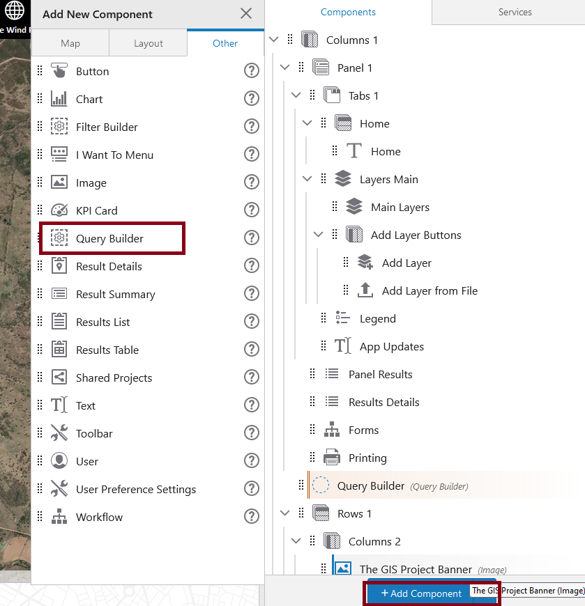
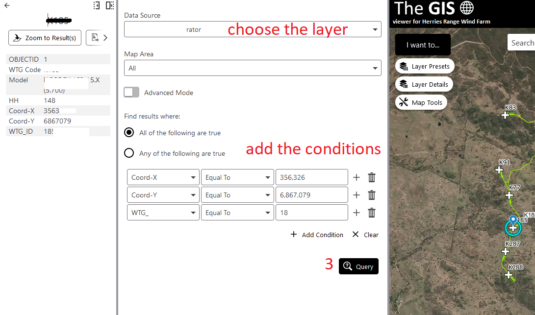
you can use query Builder from the other component, it will query the layer based on your input and return the result in the result panel. it will highlight the record in the map. see below screenshots.
 2
2 -
Thank you Rawan,
It will help for general search/ query for any layers
Lubna
0
Bitte melden Sie sich an, um einen Kommentar zu hinterlassen.
Kommentare
6 Kommentare